Falconiera Itinerary – Return to Origins
This itinerary lets you appreciate Ustica from multiple perspectives: Historical, Archaeological, Geological, and Scenic. The route also covers an important geological section of Ustica and ends at the summit of Falconiera Hill.
Symbol
Pink Square
Distance
0,75 Km
Elevation difference
100 mt
Width
2,50 mt
Trail bottom conditions
Suitable for
Adults Children and teenagers Families
Description
This is the itinerary that lets you appreciate Ustica from multiple perspectives: Historical, Archaeological, Geological, and Scenic. It starts either from Via Calvario or 100 meters north of the town hall (right at the beginning of the Tramontana trail) and includes the Roman Necropolis with Falconiera Rock, and the Florio house. The route also covers an important geological section of Ustica and ends at the top of Falconiera Hill. The path climbs uphill for 700 meters.
It’s recommended for visitors under 80 years old without mobility or respiratory issues.
Highlights
The path has two entrances: one located at the start of the Tramontana trail – right after the Town Hall – and the other in the village, to the left of Calvary. Their journey begins at the base of Falconiera hill and climbs uphill for about seven hundred meters; along the way, on the Tramontana side, you can encounter an abandoned yellow tuff quarry, once called “Calcara,” which belonged to Gaetano di Paola, nicknamed Randazzo, one of the first island representatives of the “new” colonization.
The quarry was used as early as 1763 to obtain material for building the village’s first homes and its military fortifications.
Ascending from the Calvario side, it’s fascinating to observe how the mule track was carved directly into the living rock. The work was carried out with pickaxes under Bourbon rule to allow easy access to the fortress atop the hill. The uniqueness and grandeur of this feat are also evident in the stunning exposed side sections of the walls, marked by distinct layers of ash and lapilli—remnants of the tuff formations.
Occasionally along the path, you can spot basaltic bombs resting on soft beds of unconsolidated ash, ejected during past seismic events.
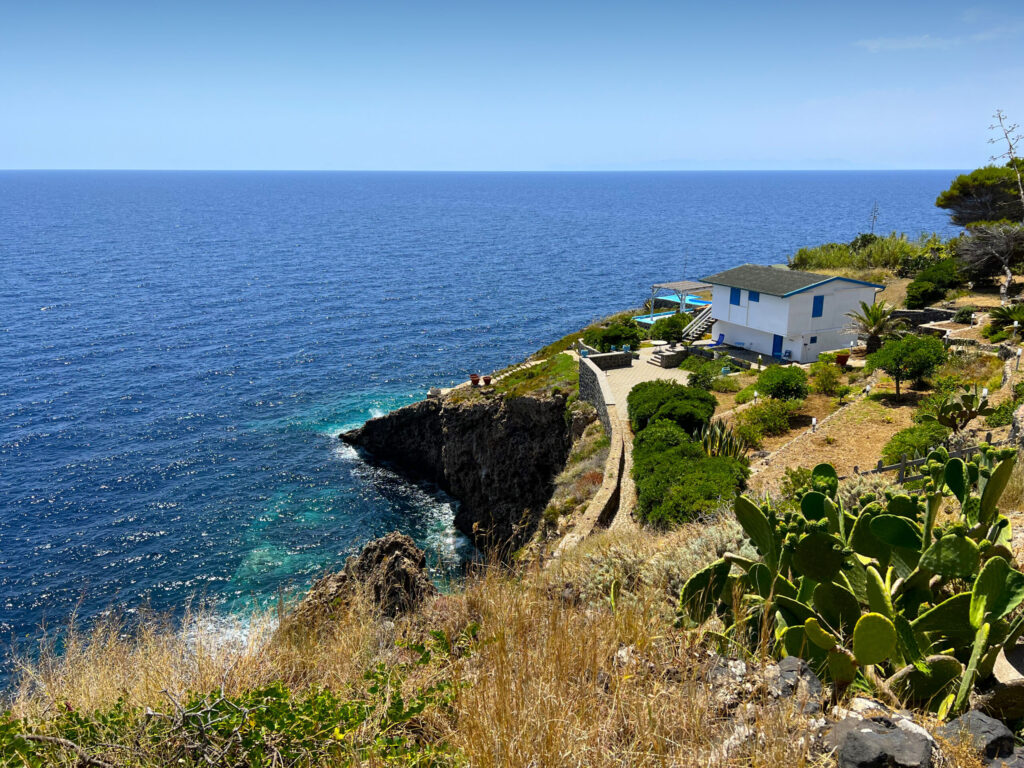
Glancing at the right slope, you’ll notice the hill is now dominated by maritime pines planted in the 1950s by the regional government as part of reforestation efforts. These were intended to stabilize the slope and prevent further landslides and collapses—phenomena that had caused repeated destruction in the past.
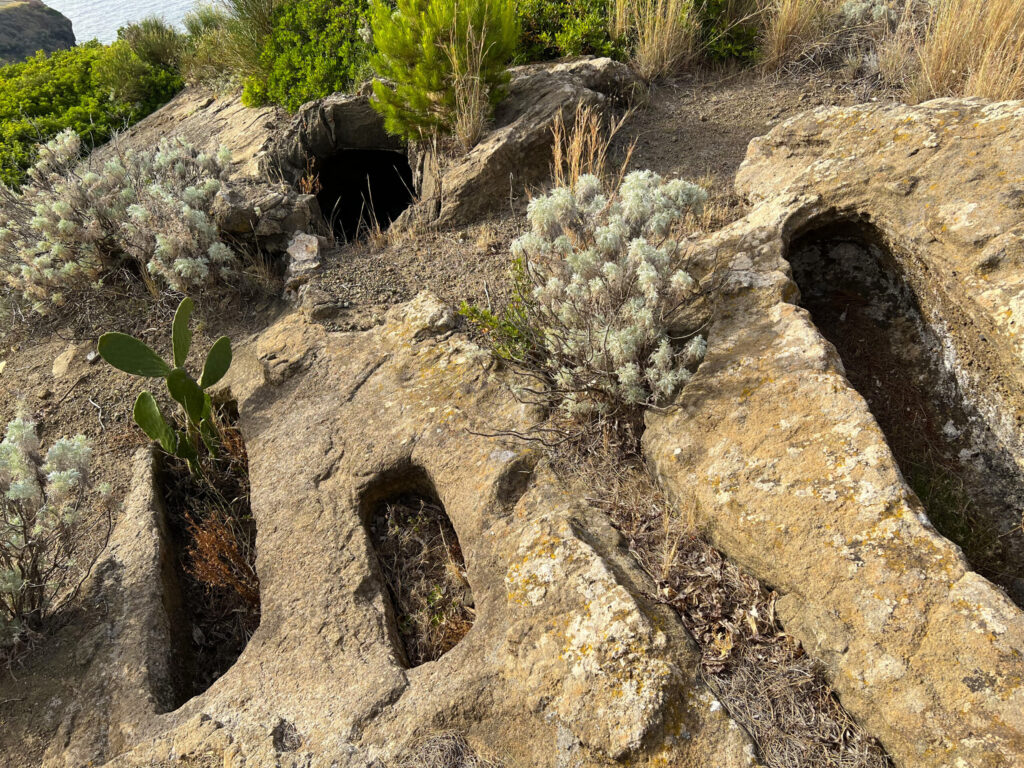
The two paths intersect halfway near the Roman hypogeal burial structures from the 5th-6th century AD carved into the hillside.
Continuing toward the summit, the route reveals eucalyptus trees on the left – obviously not native – planted in the early 1900s across the island (as elsewhere in Sicily); looking ahead, a small watchtower built to spot hostile pirate ships comes into view.
Just beyond stands the Rivellino di San Giuseppe, a defensive outpost equipped with a cannon used to warn the islanders of enemy sightings.
At the center of the two structures, a small wooden gate leads to a descending staircase that accesses the hypogeal tombs and pit graves from the late Roman period. The rock-cut burials are densely arranged along this entire slope.
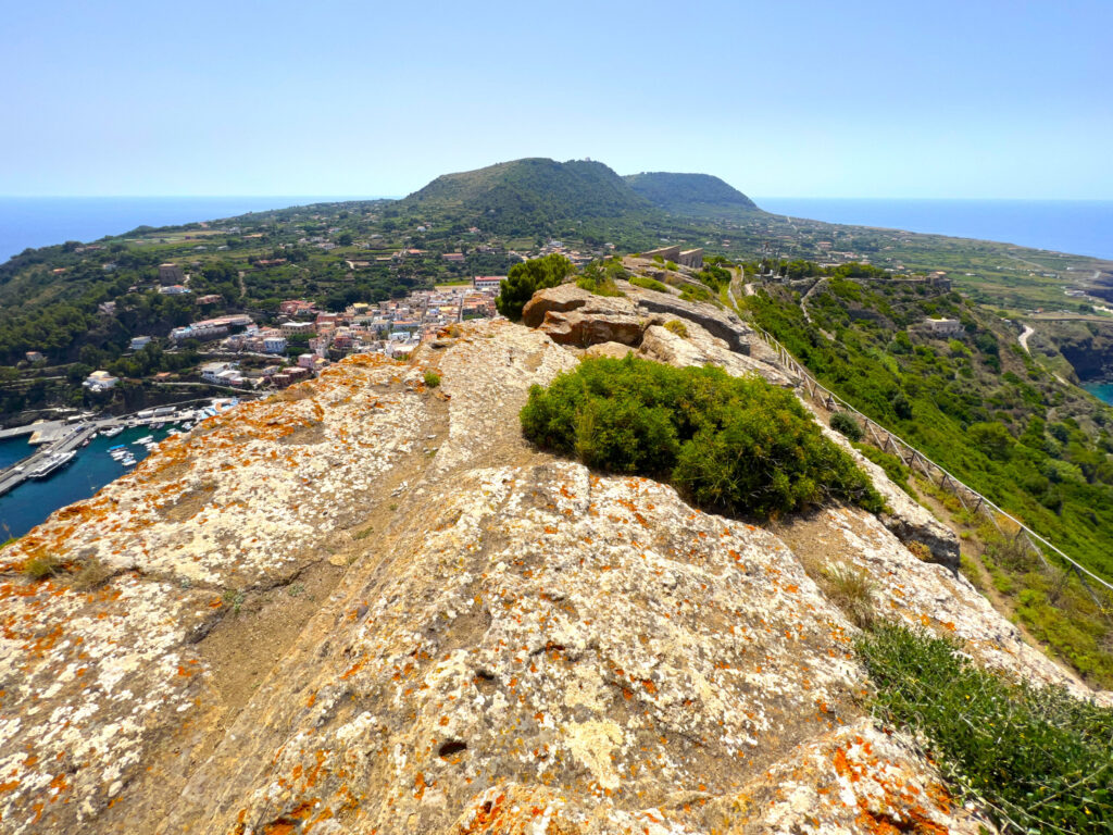
Leaving behind the military structures and climbing about twenty meters upward, we find ourselves atop Falconiera Hill. The captivating panoramic view reveals its curiously semiconic shape, covered with a blanket of mastic trees, spurge, broom, and wormwood, embraced by the vast expanse of the sea.
The hill we now stand on represents the remnant of the volcanic cone, specifically its southern edge. The cessation of eruptions and magmatic activity led to the collapse and sliding into the sea of the entire northern portion of the original volcanic structure. This was the last active volcano on the island; its final fiery breath is estimated to have occurred around 130,000 years ago.
Looking downward—where the caldera once was—you can see a complete system of drying tanks and a circular filtration setup with pumps that purify wastewater, discharging only clean water into the sea. This is the island’s treatment plant, installed in 1976 to preserve one of Europe’s most pristine marine environments.
Over the years, the facility has undergone improvements to comply with new sustainable development regulations. From 2013 to the present, the Municipality of Ustica has carried out upgrades and implemented the reuse of treated water for agricultural purposes. Agreements were made with local farms to repurpose treatment sludge as soil enrichment using “hybrid or mixed biomass” technology.
Through these wastewater system adjustments, pollutant discharges into the sea will continue to decrease, while water reuse will reduce waste and provide environmental benefits.
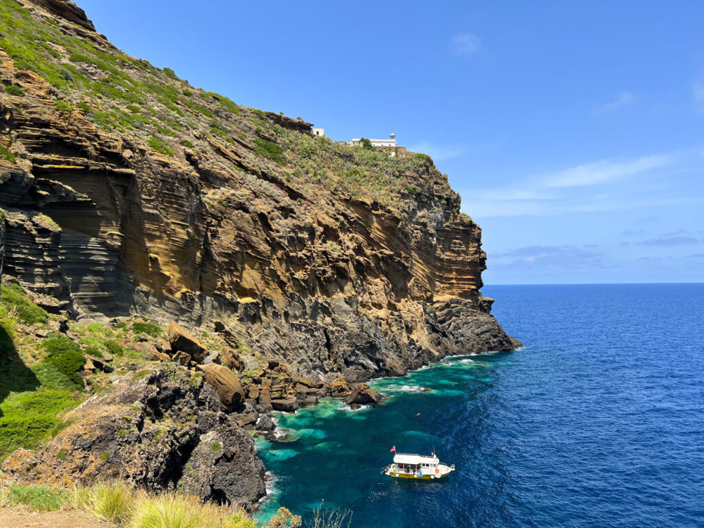
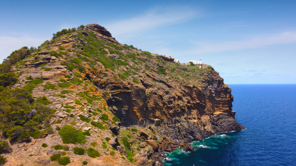
Looking eastward, suspended on the edge of the cone, we find the Faro dell’Omo Morto (Dead Man’s Lighthouse) resting at a height of one hundred meters—a place at the center of various legends explaining the ominous name given to this island outcrop.
The lighthouse was built in 1880 but was only activated four years later at a cost of thirty scudi. It serves an aeronautical and maritime function, featuring a rotating optic lens with a circumference of five hundred centimeters, housed in an octagonal tower standing over seven meters tall.
The Punta Omo Morto Lighthouse is among the most powerful in Italy, capable of projecting three long beams of light in a continuous rotating motion—so intense that their nominal range reaches 25 miles, thanks to the perfect combination of lens, glass, and elevation above sea level. Given its central Mediterranean location, it is considered one of Italy’s most important lighthouses.
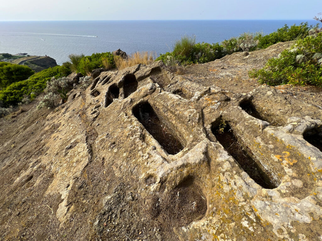
As we embark on the final stretch of the uphill path, the Rocca della Falconiera comes into view, a stronghold that served as defense and shelter for the islanders from Roman times until the Bourbon era. Remnants of settlements and sixty-nine small structures excavated for water supply can still be seen, some of which are still full of water. Those that have lost their original covering, which kept them dark, now host a rich flora of unicellular algae, as well as a carpet of duckweed (Lemna minor).
This stronghold is perched atop the hill, reaching its highest point at one hundred and fifty-seven meters above sea level. From here, you can survey most of the island, with the exception of the western sector, which is protected and hidden by the central hills. Looking south, you can glimpse the northern Sicilian coast. Chronologically predating the Rocca and clearly visible even beneath it, you can visit the troglodytic settlement, carved into the tuff during the 3rd century BC. Its very unique geographical position, natural scenery, and the clearly discernible presence of ancient dwellings make for a unique visual experience. Climbing its stairs, admiring its rock-carved chambers, and the nearly fifty cisterns essential for the survival of its inhabitants will be an unforgettable part of the Ustica experience.
Finally, one last archaeological gem: the staircase carved into the tuff by the Romans, suspended one hundred and fifty meters high over the precipice. A dizzying sight. Located in the easternmost part of the troglodytic site, it undoubtedly deserves to be seen, admired, and photographed. Unfortunately, its poor state of preservation restricts access, which is absolutely forbidden today.
The Rocca itinerary can be classified as one of the most important on the island, a path of just seven hundred meters but certainly very captivating, especially at dusk. The descent from the quarry side leads to the Tramontana path.
Recommended clothing
hiking boots, comfortable athletic wear, long pants, a water bottle, and a cap.
Important Notes
It’s the most complete trail and there are two uphill entrances
Itinerary Data
Recommended Period
from May to October
Time: From 4:00 PM to 6:00 PM