Historic Center Itinerary – Hub of Religious Activities
A historical and religious itinerary located in the urban center of Ustica, also known as the "Old Houses." The route passes through the town hall square and Via Tre Mulini, leading to the historic center.
Symbol
Dark green square
Distance
40O mt
Elevation difference
20 mt
Suitable for
Adults All Children and teenagers Families
Description
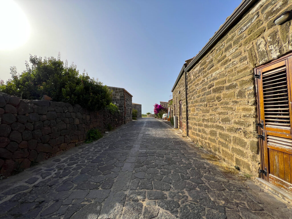
Historical/Religious Itinerary featuring the Historic Center of Ustica, also known as the “Case Vecchie” (Old Houses). From the small town square in front of the municipal building, you can directly access the Historic Center via Via Tre Mulini, which opens opposite it.
The road that runs through the entire center is distinctive: paved with basalt stones from the island using an ancient technique without cement. The small village lining its sides is entirely made of tuff and was built and inhabited by the Cistercians, an order that followed the Rule of Saint Benedict and worshipped the Madonna of the Seven Sorrows, venerated in the old church at the end of this narrow street. The small center was inhabited as early as the 12th century AD before being abandoned for 400 years.
In the 18th century, it was repopulated by settlers from Lipari, who introduced a new architectural style and a new devotion to the island’s patron saint, Saint Bartholomew, celebrated in the Church of St. Ferdinand the King—still the island’s primary religious focus today.
Highlights
The historic center settlement, also known as “the old houses,” is located north of the town center, directly facing the town hall, and stretches along a path of about 400 meters. Its origin—based on recovered pottery fragments—dates back to Roman times, where it was likely used as a farmstead.
Later documents confirm that by the mid-12th century, a Cistercian monastery stood here, housing a community that relied mainly on agriculture. Subsequent records verify that the Cistercians occupied this site until 1313. In 1219, Bishop Urso of the Church of Girgenti reported the existence of a fortified settlement and a monastery. In 1257, Pope Alexander IV, through a papal bull dated April 7, ratified the merger of the Monastery of Santa Maria di Ustica with the Cistercian Abbey of Casamari, enforcing strict adherence to Benedictine rule. In 1273, Guidone, Bishop of Agrigento, mentioned the Monastery of Ustica, and in 1313, a bull by Pope Clement V granted the Archbishop of Palermo spiritual dominion over the Island of Ustica and the Monastery of Santa Maria.
After this date, there are no further records of human presence—not only in this location but across the entire island—for four full centuries. It is believed the monks fled due to pirate raids that wreaked havoc throughout the Mediterranean.
The island was finally repopulated in 1761 by new settlers from Lipari, who reused the monastery as the only habitable structure, adapting it to their needs and redesigning the convent ruins, imprinting their architectural style—evident in features like internal courtyards and funnel-shaped pathways. By 1763, as colonists began moving into new houses built by the Bourbons in the present-day town, the “Old Houses” were repurposed as stables and haylofts.
Between the 1800s and 1900s, they were partially abandoned and used solely as animal shelters. Starting in the 1970s, many houses were restored—preserving their original dimensions, structure, and materials as a historic site—and converted into modern homes. The church, however, was split into two storage spaces, visible from the outside due to its central door being divided by a tuff-block column separating two distinct entrances.
Fortunately, the Old Church is now protected by the Superintendency of Cultural and Environmental Heritage. The monastery complex covers 5,000 square meters and consists of five irregularly shaped buildings with simple, quintessentially Cistercian architecture. The original layout included a church, sacristy, refectory, cloister, calefactory (a heated room for meditation), dispensary (a storage or workroom), kitchen, monks’ hall, lavabo, and a large cistern—all built with local materials, including gray tuff-block walls.
The church originally followed a Latin cross plan with rectangular apse and transept, typically oriented eastward. Today, it measures 4×5 meters, and the Lipari settlers later repositioned its door to the opposite side. Situated on the highest ground, it shielded other buildings from harsh northerly winds. The east-south-west sides were designed to maximize sunlight exposure. The cloister, centrally located, served as the abbey’s focal point.
The monastery’s layout lacks uniformity, adapted by monks to the terrain’s demands. Irregular pathways and the absence of right angles—hallmarks of defensive needs and wind protection—hint at Islamic urban planning influences, introduced to Sicily during the Arab conquest starting in 824 AD. The alleys were paved by settlers using basalt stones set in mud and anchored by the roots of therophytes.
Recommended clothing
Comfortable shoes, athletic and comfortable clothing, a water bottle, and a cap.
Important Notes
Today the old historic center is inhabited by locals and non-locals alike, while still preserving the original characteristics of the houses from that time.
Itinerary Data
Recommended Period
From April to October
Time: From 8:00 AM to 10:00 AM